
South Atlantic Water Science Center
South Atlantic Water Science Center
Much of the historical data and current monitoring programs focus on point-source inputs and their effect on mainstem rivers. Since the effects of nonpoint-source inputs from various land uses is poorly understood, the NAWQA Program has been designed to fill that information gap. Because the ACF River basin is too large to allow for the detailed study of each stream and aquifer, several small watersheds and aquifer systems were selected to represent a predominant land use and/or physiographic area. The term predominant land use is used to describe areas of mixed land uses that are dominated by one land-use type (e.g. 60 percent row-crop agriculture and a mix of other land uses), but are not homogeneous (e.g. 100 percent row-crop agriculture). The ideal study design for comparison of land-use effects on water quality is a system of paired watersheds having different, homogeneous land uses. The goal of NAWQA is to describe water quality in large areas of the country, however, large areas of homogeneous land use generally do not exist in the ACF River basin. Therefore, small watersheds with no point-source inputs and having mixed land use, predominated by the target land use and typical of other small watersheds in the area, were selected for study. These small watersheds, ranging from about 18-105 sq mi in area, represent a medium-sized scale of study that provides the link between small-scale studies (ie. farm-field level studies) and large-scale studies (ie. large tributaries and mainstem rivers draining mixed land uses and physiography, and containing point-source inputs). Because the goal of the study is to document water quality and describe the effects of land uses on water quality in the ACF River basin, it is necessary to study effects of land use at a medium scale, address some specific questions at a smaller scale, but ultimately be able to transfer what was learned at those scales to larger areas of the basin. It is this nested study design that will be described in greater detail in the following sections of this report.
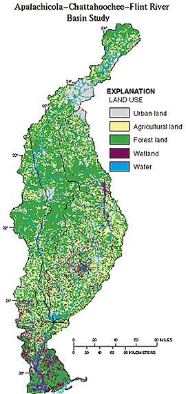
During the development of the study design, the goal was to integrate surface-water, ground-water, and biological components where possible so as to be able to document the current water quality of the study area, to begin to describe the effects of predominant land uses (27K) on that water quality, and to lay the foundation for future evaluation of the surface- and ground-water resources as an integrated system. The design primarily focuses on nonpoint-source inputs of nutrients, sediment, and pesticides from agricultural, urban, and forested land uses. The primary agricultural land uses of interest are poultry production in the headwaters of the ACF River basin (Piedmont physiographic province) and production of row crops in the southern half of the basin (Coastal Plain physiographic province). The urban land uses of interest are intensive commercial areas, such as downtown Atlanta, and suburban residential areas, such as those surrounding Atlanta. In some parts of the country forested lands represent large undisturbed areas and are suitable for collection of background information. Forested lands in the ACF River basin generally are being managed silviculturally. But even though the forested lands have been, or are being disturbed, they are the best representation of background water-quality conditions, and their effect on water quality is of value for comparison to other land uses.
Text extracted from Wangsness, 1996