
South Atlantic Water Science Center
South Atlantic Water Science Center
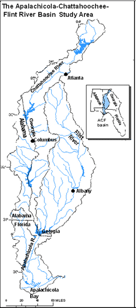
The ACF River basin NAWQA study area is about 20,400 sq mi This number includes the drainage area at the mouth of the Apalachicola River (19,600 sq mi) (U.S. Army Corps of Engineers, 1985); the New River watershed (about 510 sq. mi.) (U.S. Geological Survey digital files); and the Apalachicola Bay and surrounding coastal areas and barrier islands (about 270 sq. mi.) (U.S. Geological Survey digital files). The Chattahoochee and Flint Rivers merge in Lake Seminole to form the Apalachicola River, which flows through the panhandle of Florida into the Apalachicola Bay, and discharges into the Gulf of Mexico.
Near West Point Lake, the Chattahoochee River defines the state boundaries between Alabama and Georgia. The Flint River basin is contained entirely within Georgia. Except for the upper reaches of the Chipola River in Alabama, the Apalachicola River basin is contained within the panhandle of Florida.
Text extracted from Couch and others 1995.