
South Atlantic Water Science Center
South Atlantic Water Science Center
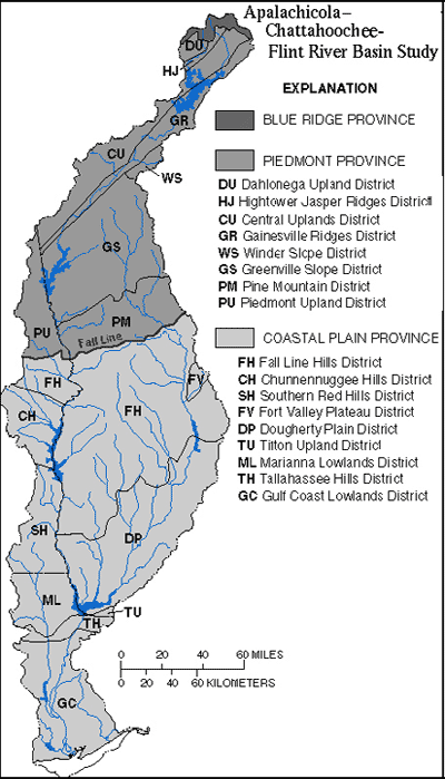
The ACF River basin contains parts of the Blue Ridge, Piedmont, and Coastal Plain physiographic provinces (17K) that extend throughout the southeastern United States. Similar to much of the Southeast, the basin's physiography reflects a geologic history of mountain building in the Appalachian Mountains, and long periods of repeated land submergence in the Coastal Plain Province. Glaciers, which influenced the physiography of much of North America, never extended to the southeastern United States. Physiography within the major provinces is not homogeneous and has been subdivided by the States of Alabama, Florida, and Georgia into the districts shown on the Physiographic Province Map. Although similar physiography may extend across state boundaries, districts may be assigned different names by state geologists in each state.
The northernmost part of the ACF River basin is within the Blue Ridge Province where headwaters of the Chattahoochee River arise. Less than one percent of the basin lies within the Blue Ridge Province. The Blue Ridge Province is dominated by rugged mountains and ridges that range in altitude from 3,000 to 3,500 feet (ft). The boundary between the Blue Ridge and the Piedmont is defined by a sharp change in slope at an altitude of approximately 1,700 ft. The Blue Ridge and Piedmont Provinces are underlain by mostly Precambrian and older Paleozoic crystalline rocks that include mica schist, felsic gneiss and schist, and granite and granite gneiss. Less extensive outcrops of quartzites are also present.
The part of the ACF River basin within the Piedmont Province in Georgia contains parts of seven physiographic districts-the Dahlonega Upland, the Hightower-Jasper Ridges, the Central Uplands, the Gainesville Ridges, Winder Slope, the Greenville Slope, and the Pine Mountain Districts (Clark and Zisa, 1976). In the Piedmont Province within Alabama, the ACF River basin lies in the Piedmont Upland District (Copeland, 1968).
The northeast trending linear-ridge structure of the Hightower-Jasper Ridges, the Central Uplands and Gainesville Ridges Districts strongly control the course of the upper Chattahoochee River and its tributaries. In particular, highly fractured faults in the Gainesville Ridges District forces the Chattahoochee River and its tributaries into a rectangular drainage pattern. Within these three ridge districts, altitudes range from about 1,500 ft in the northeast and to about 1,000 ft in the southwest. Relief, the distance between minimum and maximum altitudes, varies from approximately 500 ft in the northeast to 100-200 ft in the southwest (Clark and Zisa, 1976).
The Greenville Slope District in Georgia and the Piedmont Upland District in Alabama are both characterized by rolling topography with altitudes ranging from 1,000 ft in the Greenville Slope to 500-800 ft in the Piedmont Upland (Clark and Zisa, 1976; Copeland, 1968). Streams occupy broad, shallow valleys separated by broad, rounded divides and have dendritic drainage patterns.
The Pine Mountain District in Georgia rises abruptly from the Greenville Slope District to altitudes of 1,200-1,300 feet. The Pine Mountain District is dominated by Pine Oak Mountain, which is capped by quartzite. This district is notable for the presence of natural, warm-water springs flowing from fractured quartzite. Watersheds on the southern face of this west-to-east trending mountain ridge have rectangular drainage patterns (Clark and Zisa, 1976).
The Fall Line is the boundary between the Piedmont and Coastal Plain Provinces. This boundary approximately follows the contact between crystalline rocks of the Piedmont Province and the unconsolidated Cretaceous and Tertiary sediments of the Coastal Plain Province. As implied by the name, streams flowing across the Fall Line can undergo abrupt changes in gradient which are marked by the presence of rapids and shoals. Geomorphic characteristics of streams differ between the Piedmont and Coastal Plain Provinces. In the Coastal Plain, streams typically lack the riffles and shoals common to streams in the Piedmont, and exhibit greater floodplain development and increased sinuosity (Wharton, 1978).
The Coastal Plain Province contains three distinct regions-a hilly region immediately below the Fall Line; a region of karst topography; and a low-lying coastal region. The Fall Line Hills District in Georgia and Alabama, and the Chunnennuggee and Southern Red Hills Districts in Alabama are highly dissected with relief ranging 50-250 ft. Cretaceous sediments lie in a band immediately below the Fall Line and crop out into younger Eocene-Paleocene sediments of the low-lying Dougherty Plain District.
The Dougherty Plain and the Mariana Lowlands Districts are characterized by outcrops of the Ocala and Suwannee Limestones that result in a karst topography. The Dougherty Plain slopes southwestward with altitudes of 300 ft in the northeast to less than 100 ft near Lake Seminole. The flat to very gently rolling topography contains numerous sinkholes and associated marshes and ponds. Small streams in the Dougherty Plain District are frequently intermittent during the summer. The eastern boundary of the ACF River basin includes a small portion of the Tifton Upland District where the boundary with the Dougherty Plain is defined by the steeply sloping Pelham Escarpment. This solution escarpment continues to the northeast, forming the surface-water divide between the Flint River basin and the Ochlockonee River basin to the east.
A detailed description of physiography in the Apalachicola River basin is contained in Leitman and others (1983). The upper part of the basin lies within the Tallahassee Hills, Grand Ridge, New Hope Ridge, and Marianna Lowlands Districts. As it flows through the Tallahassee Hills District, the Apalachicola River is bordered on the east side by steep bluffs. The Tallahassee Hills District has altitudes as high as 325 ft, and is bounded on the south by the Cody Scarp, where elevations drop 15 to 20 ft to the Gulf Coast Lowlands. The Marianna Lowlands is a karst plain drained by the Chipola River, the largest tributary within the Apalachicola River basin.
The Gulf Coast Lowlands lie south of the Tallahassee Hills, Grand Ridge and New Hope Ridge Districts and extend to the Gulf of Mexico. This flat, sandy lowland was shaped by waves and currents during inundation by Pleistocene seas. This district is less than 100 ft in elevation. As the Apalachicola River flows southward through the Gulf Coast Lowlands, its floodplain broadens in width from 3 to 5 miles (mi).
Text extracted from Couch and others 1995.