
South Atlantic Water Science Center
South Atlantic Water Science Center
Three major soil orders-ultisols, entisols, and spodosols, and more than 50 soil series-are present in the ACF River basin (Hajek and others, 1975; Perkins and Shaffer, 1977; Caldwell and Johnson, 1982). Ultisols are characterized by sandy or loamy surface horizons and loamy or clayey subsurface horizons. These deeply weathered soils are derived from underlying acid crystalline and metamorphic rock. Entisols are young soils with little or no change from parent material and with poorly developed subhorizons. These soils are frequently infertile and droughty because they are deep, sandy, well-drained, and subject to active erosion. Spodosols are characterized by a thin sandy subhorizon underlaying the A horizon. This sandy subhorizon is cemented by organic matter and aluminum. The ACF River basin is similar to much of the southeastern coastal plain in the dominance of ultisols. Entisols are found at and below the Fall Line and in the Dougherty Plain; and spodosols are found in the Gulf Coast Lowlands.
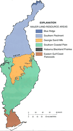
Soils of the ACF River basin are divided into six major land-resource areas (10K) (formerly called soil provinces). The Southern Piedmont, Georgia Sand Hills, Southern Coastal Plain, and Eastern Gulf Coast Flatwoods land-resource areas cover 97 percent of the ACF River basin. The Southern Piedmont land-resource area is dominated by ultisols. Piedmont ultisol soils are acid, low in nitrogen and phosphorus, and generally lack the original topsoil. Topsoil erosion began with intensive cultivation of cotton in the 1800's (Wharton, 1978).
Soils in the Southern Coastal Plain and the Georgia Sand Hills land-resource areas are derived from marine and fluvial sediments eroded from the Appalachian and Piedmont Plateaus. Ultisols are found throughout the Southern Coastal Plain, with the exception of some areas in the Georgia Sand Hills and Dougherty Plain where entisols locally are present.
The Eastern Gulf Coast Flatwoods land-resource area, which composes much of the Apalachicola River basin, is dominated by spodosols. Spodosols of the low-lying Eastern Gulf Coast Flatwoods are poorly-to-very poorly drained.
Basinwide patterns in soil leaching and runoff potential provide information on areas that may be susceptible to greater contaminant transport through infiltration or runoff. Soils with high leaching rates are concentrated in the sandy Cretaceous sediments below the Fall Line and in the sandy surficial sediments of the East Gulf Coast Flatwoods.
Runoff ratings are based on the inherent capacity of bare soil to permit infiltration, and consider slope, frequency of flooding during the growing season, and permeability (Brown and others, 1991). Soils with high runoff ratings are distributed throughout the basin, but are concentrated in areas having low permeability, steep slopes; or where flooding is frequent or the water table is near the surface, such as in floodplains and other low-lying areas. In the ACF River basin, soils with the highest runoff rate are present on steep slopes in the Blue Ridge, several areas in the Piedmont Province, the Fall Line Hills District, and in the lower Apalachicola River basin where soils commonly remain saturated.
Text extracted from Couch and others 1995.