
South Atlantic Water Science Center
South Atlantic Water Science Center
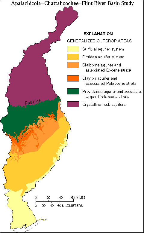
Six major aquifers underlie the ACF River basin. These aquifers, listed in descending order, are the surficial aquifer system, the Floridan aquifer system, the Claiborne aquifer, the Clayton aquifer, the Providence aquifer, and the crystalline rock aquifer. Generalized outcrop areas and stratigraphy of aquifers underlying the Coastal Plain Province (11K); generally are separated by confining units.
Aquifers in the Coastal Plain Province consist of alternating units of sand, clay, sandstone, dolomite, and limestone that dip gently and thicken to the southeast. Confining units between these aquifers are mostly silt and clay. From the Fall Line to the Gulf of Mexico, progressively younger sediments crop out and overlie older sediments. The complex interbedded clastic rocks and sediments of Coastal Plain aquifers range in age from Quaternary to Cretaceous. Because of gradational changes in hydrologic properties, aquifer and stratigraphic boundaries are not always coincident.
The surficial aquifer system is a shallow, mostly unconfined water-table aquifer consisting of cross-bedded sand, gravel and clay with undifferentiated alluvium near rivers. Surficial deposits are associated with all outcrop areas shown on the Generalized Outcrop map. However, only in the southern part of the ACF River basin do these deposits contain ground water whose use warrants mapping as a single aquifer (Miller, 1990). Isolated domestic wells withdraw water from the surficial aquifer system.
The Floridan aquifer system, one of the most productive aquifers worldwide, underlies about 100,000 sq mi in Florida, southern Alabama, southern Georgia, and southern South Carolina. The Floridan aquifer system comprises of a thick sequence of carbonate rocks that are of Tertiary age and are hydraulically connected in varying degrees (Miller, 1986). The Ocala Limestone is one of the thickest and most productive formations that crops out in the Dougherty Plain and gives rise to a karst topography riddled with sinkholes. The complex hydrogeology of the Floridan aquifer system is reflected by highly variable transmissivities that range from 2,000 to 1,300,000 feet squared per day (sq ft/d). Range in transmissivities in the Ocala Limestone is caused by the variable, fractured nature, and the dissolution of limestone that creates conduits and solution openings (Miller, 1986).
The Tallahatta Formation of Eocene age is the principal water-bearing formation of the Claiborne aquifer (McFadden and Perriello, 1983). The Clayton Formation of Paleocene age is the water-bearing formation of the Clayton aquifer. Cretaceous units crop out immediately below the Fall Line. The principal water-bearing formation is the Providence Sand of Late Cretaceous age (McFadden and Perriello, 1983). Older Cretaceous strata generally are too deep to be economically developed.
Aquifers in the Piedmont and Blue Ridge Provinces are in crystalline rocks that crop out in the northern part of the basin and extend to the Fall Line. These crystalline rocks have similar hydraulic characteristics and are mapped as one aquifer. The metamorphic and igneous crystalline rocks of the crystalline aquifer are overlain by pockets of regolith (weathered, unconsolidated rock debris) of varying thicknesses. The greatest thicknesses of regolith, as much as about 100 ft, are in draws and valleys. Because the crystalline rocks have few primary pore spaces, ground water is obtained primarily from the regolith and from fractures in the rock. Reported yields of wells completed in these rocks range from zero to 471 gallons per minute (gal/m), but are commonly less than 50 gal/m (Cressler and others, 1983; Chapman and others, 1993).
The regional direction of ground-water flow is from north to south; however, local flow directions vary, especially in the vicinity of streams and areas having large ground-water withdrawals. Rivers and streams in the Coastal Plain Province commonly are deeply incised into underlying aquifers and receive substantial amounts of ground-water discharge. Strata associated with the Floridan aquifer system are exposed along sections of the Apalachicola, Chattahoochee, and Flint Rivers; and Spring Creek (Maslia and Hayes, 1988). As a result of the hydraulic connection between the Floridan aquifer system and the Flint River, ground-water discharge contributes more significantly to baseflow in the Flint River than in the Chattahoochee River. Aquifer discharge to the Chattahoochee River is estimated to be one-fifth of the amount that discharges to the Flint River (Torak and others, 1993).
Text extracted from Couch and others 1995.