
History of USGS-State of Georgia Cooperative Water-Quality Monitoring Program
- Late 1930's (1937) - early 1940's -- QW assessment by USGS of surface- and ground-water quality in cooperation with the Division of Mines, Mining, and Geology of the Georgia Department of Natural Resources. Water quality analytical results were reported in USGS WSP 912 (1942) and USGS WSP 889-E (1944) by William Lamar.
- 1957 - 1958 -- QW reconnaissance study of Georgia's streams in cooperation with Georgia State Division of Conservation, Department of Mines, Mining, and Geology. QW analytical results reported in The Geological Survey Bulletin No. 69 (Georgia) (1961) by Rodney N. Cherry.
- 1964 -- Georgia Water Quality Control Act established the Georgia Water Quality Control Board.
- 1968 -- QW data collection program in cooperation with Georgia Water Quality Control Board, and other State agencies. Sample collection conducted by USGS once-monthly at a fixed network of locations across the State, many of which are still being monitored today.
- 1972 -- Environmental Protection Division (EPD) of the Georgia Department of Natural Resources is established by the Executive Reorganization Act, signed into law April 6, 1972 by then Governor Jimmy Carter. The cooperative QW program between USGS and the State of Georgia fell under this Division of the Georgia Department of Natural Resources since the Georgia Water Quality Control Board was abolished by this Act. USGS continues to collect water-quality data in cooperation with Georgia EPD at a fixed network of stations across the State.
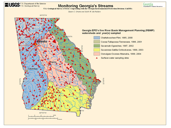
- 1992 – River Basin Planning Act: Georgia established a river basin management planning approach to watershed protection as defined by State law (O.C.G.A. 12-5-520 to 525). Under this Act, assessment of the 14 major river basins in Georgia on a 5-year cycle was required and included development and implementation of a basin management plan to monitor and protect water quality in the State. The 14 major river basins in Georgia were grouped into five management-planning basins.
- 1968 – 1994: USGS collects and manages water-quality data in cooperation with Georgia EPD at a network of fixed stations across the State.
- 1993-95: The Georgia River Basin Management Plan (RBMP) is drafted and implemented.
- 1995: USGS begins QW data collection and data management in cooperation with Georgia EPD under the new RBMP. The Chattahoochee-Flint RBMP basin is monitored intensely during calendar year 1995 along with the fixed network of statewide long-term monitoring stations.
- 1996: USGS continues QW data collection and data management in cooperation with Georgia EPD under the new RBMP. The Coosa-Tallapoosa-Tennessee RBMP basin and the Oconee River basin are monitored intensely during calendar year 1996, along with the fixed network of statewide long-term monitoring stations.
- 1997: USGS continues QW data collection and data management in cooperation with Georgia EPD under the new RBMP. The Savannah-Ogeechee RBMP basin is monitored intensely during calendar year 1997, along with the fixed network of long-term statewide monitoring stations.
- 1998: USGS continues QW data collection and data management in cooperation with Georgia EPD under the new RBMP. The Satilla-Suwannee-St Marys-Ochlockonee RBMP basin (“South GA 4”) is monitored intensely during calendar year 1998, along with the fixed network of long-term statewide monitoring stations.
- 1999: USGS continues QW data collection and data management in cooperation with GA EPD under the new RBMP. The Oconee-Ocmulgee-Altamaha RBMP basin (“Middle GA 3”) is monitored intensely during calendar year 1999, along with the fixed network of long-term statewide monitoring stations.
- 2000: In keeping with the 5-year TMDL development cycle, USGS returns to the Chattahoochee-Flint RBMP basin for intensive monitoring during calendar year 2000, along with the fixed network of long-term statewide monitoring stations.
- 2001: In keeping with the 5-year TMDL development cycle per the RBMP, USGS returns to the Coosa-Tallapoosa-Tennessee RBMP basin for intensive monitoring during calendar year 2001, along with the fixed network of long-term statewide monitoring stations.
- 2002: In keeping with the 5-year TMDL development cycle per the RBMP, USGS returns to the Savannah-Ogeechee RBMP basin for intensive monitoring during calendar year 2002, along with the fixed network of long-term statewide monitoring stations.
- 2003: In keeping with the 5-year TMDL development cycle per the RBMP, USGS returns to the “South GA 4” RBMP basin for intensive monitoring during calendar year 2003, along with the fixed network of long-term statewide monitoring stations.
- 2004: In keeping with the 5-year TMDL development cycle per the RBMP, USGS returns to the “Middle GA 3” RBMP basin for intensive monitoring during calendar year 2004, along with the fixed network of long-term monitoring stations.
- 2004: 2004 Comprehensive State-wide Water Management Planning Act-- Georgia General Assembly mandates Georgia EPD develop a State-wide Water Management Plan (O.C.G.A 12-5-522 (a))
- 2005: USGS-Georgia EPD cooperative agreement redirects focus of cooperative QW program to the Coosa River basin TMDL re-study, a network of over 60 continuous and discrete monitoring stations, along with the fixed network of long-term statewide monitoring stations. This was a multi-agency monitoring effort involving mainly USGS and Georgia EPD, but also included USEPA and the Alabama Department of Environmental Management (ADEM).
- 2006: Cooperative QW monitoring focuses exclusively on the statewide long-term monitoring stations for calendar year 2006.
- 2007: USGS resumes monitoring in support of the 5-year TMDL cycle focusing on the Savannah-Ogeechee RBMP basin during calendar year 2007, along with the fixed network of long-term monitoring stations.
- 2008: USGS resumes monitoring in support of the 5-year TMDL cycle focusing on the “South GA 4” RBMP basin monitoring during calendar year 2008, along with the fixed network of long-term monitoring stations.
- 2009 – present: USGS – Georgia EPD Cooperative QW monitoring focuses exclusively on the statewide long-term and lake-standards monitoring stations during each calendar year.