Chattahoochee River National Recreation Area
The Chattahoochee River National Recreation Area (CRNRA) is a National Park Service unit/park with 48 miles of urban waterway in the Atlanta metropolitan area, Georgia. In 2018, the CRNRA had 2,873,866 visitors and economic contributions of about 128 million dollars in visitor spending and 179 million dollars in economic output (Cullinane and others; 2019). Approximately 30 percent of the park visitation involves water-based recreation, including primary contact activities such as swimming and tubing, and secondary contact activities including canoeing, kayaking, boating, rowing, wading, and fishing.
- Cullinane, T.C., Koontz, L., and Cornachione, E., 2019, 2018 National Park visitor spending effects—Economic contributions to local communities, States, and the Nation: Natural Resource Report NPS/NRSS/EQD/NRR—2019/1922, Fort Collins, Colorado, National Park Service, 55 p., accessed April 20, 2020, at https://www.nps.gov/nature/customcf/NPS_Data_Visualization/docs/NPS_2018_Visitor_Spending_Effects.pdf.
ChattFacts
- These ChattFacts were compiled by the Upper Chattahoochee Riverkeeper
- In 1978, Congress created the Chattahoochee River National Recreation Area consisting of 48 miles of the River (Buford Dam to Peachtree Creek) and authorized the National Park to purchase 10,000 acres of land in units along the River. To date, over 5,000 acres have been purchased.
- "Chattahoochee" is a Creek Indian word which means "river of painted rocks".
- The Chattahoochee River begins in the north Georgia mountains at a spring on Coon Den Ridge in southeastern Union County.
- The headwaters of the Chattahoochee River above Atlanta comprise the smallest watershed, or drainage area, which provides a major portion of water supply for any metropolitan area in the country.
- The Chattahoochee River supplies 70% of metro Atlanta's drinking water, which is more than 300 million gallons per day. It is also used for industrial supply, irrigation, power generation, navigation and recreation and is considered to be the most heavily-used water resource in Georgia.
- Metro Atlanta's sewage treatment plants release more than 250 million gallons of treated wastewater each day into the Chattahoochee River.
- In the upper Chattahoochee River basin (Helen to West Point Dam), 159 municipalities and industries are permitted to discharge specific levels of pollutants into the River.
- Basin hydrology and water quality are influenced by 14 mainstem reservoirs.
- In 1957, the Corps of Engineers completed Buford Dam, 50 miles above Atlanta, and created Lake Lanier, the most visited federal lake in the United States. Lake Lanier contains 38,000 acres and 540 miles of shoreline.
- The CRNRA attracts approximately 3 million visitors each year .
- The Chattahoochee River flows southwesterly 436 miles to the Florida border, defining the state boundaries between Georgia and Alabama near West Point Lake.
- The Chattahoochee River drains 8,770 square miles.
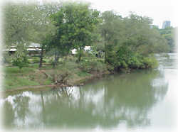
Medlock Bridge Site
The Medlock Bridge gage is the northernmost sampling location. It is above Morgan Falls Lake and near numerous residential areas, a large popular golf course, and the Medlock Bridge National Park Service Unit. It is located on Medlock Bridge Road. This area is used regularly by nearby residents but is not as popular as the two sampling locations downstream.
Sampling Site
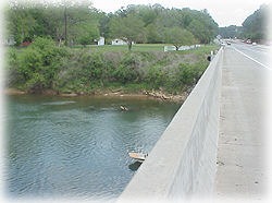
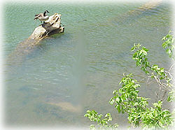
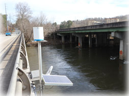
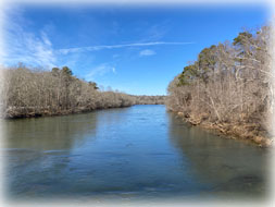
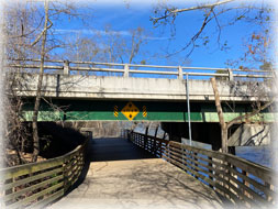
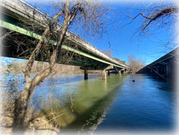
Bacteria samples are collected by the Chattahoochee Riverkeeper on Medlock Bridge Road. The sampling location is at USGS Chattahoochee River at Norcross (Medlock Bridge), which is also on the downstream side of Medlock Bridge Road, a large four-lane divided highway (left photo). The right picture shows the surrounding area on the other side of the bridge.
Adjacent Land Use
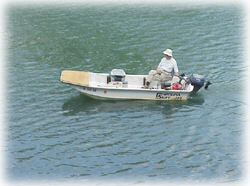
Public use of the Chattahoochee River at the Medlock Bridge area is less intense than at the other two locations where sampling is conducted. Fishing from a boat or kayak is a popular activity, and boaters (left photo) are often observed in the river. There are limited walking trails and no swift shoals at the Medlock Bridge boat ramp. Further downstream is the National Park Service's Jones Bridge Unit, which is very heavily used by picnickers, waders, hikers, and dog-walkers.
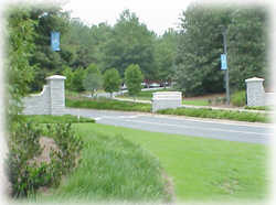
Surrounding Area
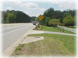
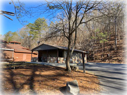
The immediate area consists of suburban residential and large highways, such as Hwy 141, shown in the left picture. There is a lot of growth occurring along the highway, and much of the land continues to experience commercial, residential, and business development. Since the immediate area does not consist of public parks and land reserves, such as at the National Park Service units further downstream, more of the land consists of nonpermeable cover, such as roads, parking lots, and houses.
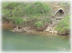
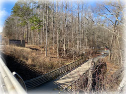
The right picture shows a stormwater outfall pipe, which is located next to the bridge on the upstream side. Although storm water off of the adjacent land mainly runs into the river along the banks, the sewer is a point-source location for direct runoff for debris, oils, and other matter from Hwy 141. Runoff from roads is a concern, as it can detrimentally affect water quality, which is a special concern for a highly-used river such as the Chattahoochee.
Powers Ferry Site
The Powers Ferry gage is located in the lower two-thirds of the basin covered by the BacteriAlert project. The area is moderately urbanized and full of public activity. Nearby there are residential areas, restaurants and commercial establishments. Both sides of the river immediately upstream are surrounded by walking paths on National Park Service Property and residences. This is a very popular section of the Chattahoochee River.
Sampling Location
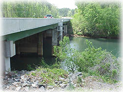
Bacteria samples are collected by the Chattahoochee Riverkeeper at the USGS Chattahoochee River at Powers Ferry gaging station (gage is in the upper left photo). Sampling is usually conducted from the Interstate-North Parkway bridge.
Adjacent Land Use
The Chattahoochee River at Powers Ferry gage is located at the National Park Service Cochran Shoals Unit. These parks contain walking trails and boat ramps that are used frequently by the public. Upstream of the park are several residential neighborhoods. Downstream there are several businesses and restaurants frequented by locals.
Surrounding Area
The area surrounding the Powers Ferry sampling location is the most publicly utilized area of all the sampling locations. It is a popular boat ramp during the summer months. Fishing occurs in this area throughout the year. The walking paths experience numerous visitors every day as locals enjoy the outdoors jogging or walking dogs.
This location is less urbanized in the immediate vicinity of the sampling location but its consistent public use as a pedestrian and dog walking area may have some effect on the levels of bacteria in the river.
Paces Ferry Site
The Paces Ferry gage is the southernmost sampling location. The immediate area is highly urbanized and full of public activity. Nearby there are residential areas, restaurants and commercial establishments, a shopping mall, and high-rise office buildings. There is a large, private school along the river bank. Tens of thousands of people live, work, and play close to this section of the Chattahoochee River.
Sampling Location
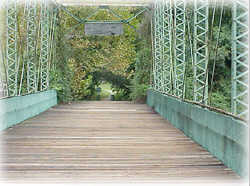
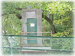
Bacteria samples are being collected by Chattahoochee Riverkeeper at the USGS Chattahoochee River at Atlanta (Paces Ferry) gaging station (gage house is in the right picture). Sampling is usually conducted using the renovated one-lane iron truss bridge that crosses the river at Paces Ferry Road (left picture).
Adjacent Land Use
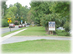
The Chattahoochee River at Paces Ferry Road is located just east of Vinings and is downstream of I-75 and I-285. The surrounding area is densely developed. On the right bank (facing south, downstream) is a restaurant (left picture) and shopping center, and upstream on the left bank is a large private school (right picture).
Surrounding Area
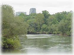
The area surrounding the Paces Ferry sampling location is very heavily used by the people of Atlanta for a variety of uses. Just upstream of the site is the National Park Service's Palisades Unit, which is frequented by picnickers, hikers, boaters, and rafters. The area is a popular boat ramp for thousands of tubers and rafters finishing their float down the Chattahoochee during the summer months. Many people picnic and hike the trails and climb the rocky bluffs of the river further upstream of the gage.
As the left-side picture shows, high-rise office centers and shopping districts are situated just upstream of the gage, and Paces Ferry Road at the sampling site supports shopping and is an important traffic artery (right picture).