Groundwater Resources and Hydrogeology of Crystalline-Rock Aquifers in Rockdale County, North-Central Georgia
Project Chief: Bryan Hughes
Cooperator: Rockdale County
Year started: 2001
THIS PROJECT HAS BEEN COMPLETED AND IS BEING ARCHIVED IN ITS FINAL CONFIGURATION
Problem

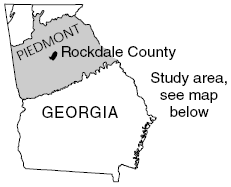
Ground water in crystalline rocks of the State has not been extensively tapped as a source of public drinking water. This source, however, may prove to be a valuable resource to communities wishing to supplement their existing surface-water supplies and augment the amount of available drinking water in rapidly-growing areas of north Georgia, such as in Rockdale County (map, right). Little information is available to evaluate fully the quantity and quality of ground-water resources in the area. Because geology is the principal control on the availabilityof ground water, the U.S. Geological Survey (USGS) is conducting this study, in cooperation with Rockdale County, to determine the rock types and geologic structures that influence ground-water availability. Ultimately, this information will increase the understanding of how ground water flows through complex crystalline-rock aquifer systems and provide critical information for the future development and management of this resource.
Objectives
- Evaluate the hydrogeology and ground-water resources of the study area.
- Provide baseline geologic and hydrologic information for a typical crystalline-rock aquifer setting in northern Georgia.
- Determine the hydraulic characteristics and storage potential of water-bearing zones/hydrogeologic units at various well sites.
- Define the best methods and approaches to characterize the availability of ground water in crystalline-rock areas.
- Develop a better understanding of crystalline-rock aquifer systems so that State and local water-management agencies can use this information when developing groundwater use policies.
Progress and Significant Results, 2002—2003
- Compiled data on approximately 450 wells (primarily rural domestic) including field confirmation of well location, casing diameter, well yield, casing depth, total depth, and static/pumping water level.
- Obtained geophysical logs from 19 wells to characterize the lithology, fracture, and yield characteristics of various rock units throughout Rockdale County.
- Collected ground-water samples from three wells to characterize water quality.
- Completed detailed geologic mapping throughout much of Rockdale County and began subsurface correlation with geophysical log data; hydrogeologic units and storage capabilities are being compiled from these data.
- Identified likely high-yielding water-bearing zones/hydrogeologic units in several parts of Rockdale County.
- Currently compiling a geographic information system database to combine well data with existing geologic, topographic, hydrographic, and other geographic data.
Progress and Significant Results, 2001
- Compiled data on approximately 450 wells (primarily rural domestic) including field confirmation of well location, casing diameter, well yield, casing depth, total depth, and static/pumping water level.
- Obtained geophysical logs from 19 wells to characterize the lithology, fracture, and yield characteristics of various rock units throughout Rockdale County.
- Collected ground-water samples from three wells to characterize water quality.
- Completed detailed geologic mapping throughout much of Rockdale County and began subsurface correlation with geophysical log data; hydrogeologic units and storage capabilities are being compiled from these data.
- Identified likely high-yielding water-bearing zones/hydrogeologic units in several parts of Rockdale County.
- Currently compiling a geographic information system database to combine well data with existing geologic, topographic, hydrographic, and other geographic data.
