Geohydrology of Fractured Crystalline Rock of Northern Georgia
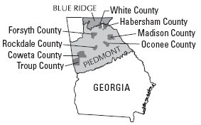
Cooperator: Coweta County, Forsyth County, Oconee County, Rockdale County, Troup County
Year started: 2007
THIS PROJECT HAS BEEN COMPLETED AND IS BEING ARCHIVED IN ITS FINAL CONFIGURATION
Problem

Groundwater development and use in the fractured crystalline
rocks of northern Georgia are critical to sustain population growth and economic development. Knowledge about ground-water movement, storage, vulnerability, quality, and connection
with surface-water resources is limited because of the complexity of fractured-rock aquifers that underlie the region. A better understanding of the relation between the complex geology and ground-water resources in these areas is needed for water-resource managers and planners to develop effective management
strategies and optimize available supply for future use.
Objectives
The primary objective is to evaluate the occurrence and quality of ground water in fractured crystalline rock of the Piedmont and Blue Ridge physiographic provinces of northern Georgia. Specific objectives are to:
- Compile existing information on geology and wells.
- Conduct a field inventory of existing wells to verify construction, yield, and location.
- Collect borehole geophysical and flowmeter logs to determine depth, yield, and geologic and water-quality characteristics of water-bearing intervals.
- Evaluate geologic, well, and borehole geophysical data
to identify geologic settings favorable for the development of sustainable water supplies.
- Establish a ground-water-level monitoring network for northern Georgia.
- Develop and maintain a comprehensive geohydrologic database of well and geophysical data.
This investigation provides information to help guide future ground-water development and water-management decisions for local communities while enhancing understanding of the hydrogeology of fractured rocks in the southern Piedmont and Blue Ridge physiographic provinces. Data from this study are entered into the USGS National Water Information System (NWIS) and are available on the Web at https://waterdata.usgs.gov/ga/nwis/inventory/.
Progress and Significant Results, 2006—2007
- Coweta County—Developed plan of study to include well inventory and borehole geophysical logging in selected wells.
- Forsyth County— Collected borehole geophysical logs and conducted borehole flowmeter traverse in two wells located along the Chattahoochee River north of Littles Ferry Bridge. Developed plan of study for well-inventory program.
- Oconee County— Collected borehole geophysical logs, grab water samples, and conducted borehole flowmeter traverse in two wells near the town of Watkinsville to evaluate causes of water-quality problems in the well water. In one well, dissolved carbon dioxide was being emitted; water in the
other well was contaminated by iron bacteria.
- Troup County— Completed compilation of data and field well inventory. Data for 138 wells were added to the existing 79-well NWIS database, which increased the total to 217 wells. Developed spatial hydrological data layers for wells and surficial geology. Began preparation of final report.
- Rockdale County— Collected borehole geophysical logs in two test wells located adjacent to production wells in the Conyers area to determine structural orientations of fractures and bedrock foliation. This information was used to help assess the interconnection between test wells and production wells as a follow-up to aquifer testing conducted during 2005 (Williams and Cressler, 2007).
- Other areas—In addition to the efforts in each of these counties, borehole geophysical logs were collected at several other sites in the Piedmont and Blue Ridge Provinces,
including two wells in White County, one well in Habersham County, and one well in Madison County.
- Outreach—Prepared a Fact Sheet describing how borehole geophysical logs can provide valuable information to evaluate ground-water resources in fractured crystalline rock (U.S. Geological Survey, 2007). The Fact Sheet describes the types of data collected and how these data are used to evaluate the water-bearing characteristics of fractured crystalline rock.
See https://pubs.usgs.gov/fs/2007/3048/.
Publications
Well Inventory and Geophysical Logging of Selected Wells in Troup County, Georgia, 2007—2008
This report is available online only in pdf format (2 Mb): U.S. Geological Survey Scientific Investigations Map 3058, 1 page
Note: This report is a poster that is 42 inches wide by 32 inches high.
Johnson, Carole D.,Williams, John H., and Williams, Lester J., Hydraulic logging methods--A summary of field methods used in fractured bedrock systems, Georgia (231 kb PDF file)
Khallouf, Donna D., and Lester J. Williams, Structural and lithologic controls on ground-water availability in a granite and biotite gneiss in the Conyers, Georgia, area (204 kb PDF file)
