
South Atlantic Water Science Center
South Atlantic Water Science Center
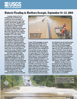
 Many days of continuous heavy rain in mid-September resulted in record flooding in many parts of Georgia, especially in north Georgia and the Atlanta region. This picture shows flooding at Dog River at Hwy 5, Douglas County, Georgia on September 21, 2009. The deck holds the USGS automated water-monitoring and transmission equipment that allows for real-time display of current stream conditions on our Web pages.
The flooding around Atlanta this week is one for the record books. According to the U.S. Geological Survey (USGS), the rivers and streams had magnitudes so great that the odds of it happening were less than 0.2 percent in any given year. In other words, there was less than a 1 in 500 chance that parts of Cobb and Douglas counties were going to be hit with such an event.
"The USGS can reliably say just how bad these floods were. They were epic!" said Brian McCallum, Assistant Director for the USGS Water Science Center in Georgia. "We have all witnessed the devastation caused by these floods, but now we can quantify it." The data are gathered from the USGS real-time streamgaging network.
In the Atlanta area:
"On Sept. 26th, 6 USGS crews were installing and repairing the 20 gages that were destroyed because of flooding. We expect that all but one gage should be operational by the end of the day," said McCallum. "During flooding, these gages provide critical information to many users, so fixing the gages is our priority now."
In Georgia the USGS maintains a network of more than 300 stream gages that provide data in real time. Data from these gages are used by local, state and federal officials for numerous purposes, including public safety and flood forecasting by the National Weather Service.
 Fact Sheet 2010-3061
Historic Flooding in Northern Georgia, September 16-22, 2009