Simulation and Particle-Tracking Analysis of Selected Groundwater Pumping Scenarios at Vogtle Electric Generation Plant
Project Chief: Gregory C. Cherry
Cooperator: U.S. Nuclear Regulatory Commission
Year started: 2007
THIS PROJECT HAS BEEN COMPLETED AND IS BEING ARCHIVED IN ITS FINAL CONFIGURATION
Problem

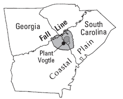
The Vogtle Electric Generation Plant (VEGP), in Burke County, Georgia, is one of Southern Company's two nuclear-generating facilities in Georgia. On August 15, 2006, Southern Nuclear Company applied to the U.S. Nuclear Regulatory Commission (NRC) for an early site permit (ESP) for an additional two reactors at the site. As part of the ESP permitting process, the NRC is charged with development of an environmental impact statement (EIS) to evaluate the effects of constructing and operating these new reactors on
the site and surrounding area. The EIS must describe the magnitude and nature of expected effects on ground water resulting from present and potential future ground-water withdrawal. The assessment should include the area of VEGP and extend for distances great enough to cover potentially affected aquifers, including those within the boundary of the U.S. Department of Energy, Savannah River Site (SRS), located in South Carolina across the Savannah River from VEGP. The addition of two new reactors (Units 3 and 4) at VEGP will require an increase in pumping from the lower Dublin and upper and lower Midville aquifers, which currently provide the water needed for reactor Units 1 and 2. NRC would like to evaluate the effects of additional pumpage on ground-water flow in the surrounding area.
Objectives
- Simulate the effect of current (2002) and potential future pumping on ground-water levels and flow
paths near VEGP for three pumping scenarios in a 4,455-square-mile area near Augusta, Georgia.
- Compare simulated water levels to a Base Case representing 2002 pumping rates throughout the model area.
- Conduct a particle-tracking analysis for each scenario to determine the source of water for VEGP production wells.
- Describe the pumping distribution, simulated water-level changes, and ground-water flow paths relative to the Base Case.
- Define the limitations of the model analysis.
Publications
Simulation and Particle-Tracking Analysis of Selected Ground-Water Pumping Scenarios at Vogtle Electric Generation Plant, Burke County, Georgia - USGS Open-File Report 2007-1363.
Progress and Significant Results, 2006—2007
- An updated and calibrated MODFLOW ground-water flow model (Cherry, 2006) was used to simulate the effect of current and potential future pumping on ground-water levels and flowpaths near VEGP for a Base Case representing
year 2002 conditions and three pumping scenarios (see table). The pumping scenarios focused on pumping increases at VEGP based on projected future demands and the addition of two electrical-generating reactor units. Scenarios simulated pumping increases at VEGP ranging
from 1.09 to 3.42 million gallons per day (Mgal/d), with one of the scenarios simulating the elimination of 5.3 Mgal/d of pumping at the SRS. The largest simulated
water-level changes at VEGP were for the scenario whereby pumping at the facility was more than tripled, resulting in drawdown exceeding 4-8 feet (ft) in the aquifers
screened in the production wells. For the scenario that eliminated pumping at SRS, water-level rises of as much as 4-8 ft were simulated in the same aquifers at SRS.
- Results of MODFLOW simulations were analyzed using
the U.S. Geological Survey particle-tracking code MODPATH to determine the source of water and associated time of travel to VEGP production wells. For each of the scenarios, most of the recharge to VEGP wells originated in an upland area near the Burke and Jefferson County line. None of the recharge originated on the SRS or elsewhere in South Carolina.
An exception occurs for the scenario whereby pumping at VEGP was more than tripled. For this scenario, some of the recharge originates in an upland area in eastern Barnwell County, South Carolina. Simulated mean time of travel from recharge areas to VEGP wells for the Base Case and the three other pumping scenarios was between about 2,700 and 3,800 years, with some variation related to changes in head gradients because of pumping changes.
Reference
Cherry, G.S., 2006, Simulation and particle-tracking analysis of ground-water flow near the Savannah River Site, Georgia and South Carolina, 2002, and for selected water-management scenarios, 2002 and 2020: U.S. Geological Survey Scientific Investigations Report 2006-5195, 156 p.; Web-only publication available at https://pubs.usgs.gov/sir/2006/5195/.
