Hydrogeology and Impact of Pumping on Shallow Water-Bearing Zones and the Upper Floridan Aquifer, South-Central Georgia
Project Chief: Brian Hughes
Cooperator: Georgia Department of Natural Resources, Environmental Protection Division
Year started: 2007
THIS PROJECT HAS BEEN COMPLETED AND IS BEING ARCHIVED IN ITS FINAL CONFIGURATION
Problem
 During the drought conditions of 2007, ground-water-level declines in south-central Georgia have resulted in numerous domestic wells "going dry," requiring pumps to be lowered or drilling of replacement wells. The cause of the declines is unknown but could be related to reduced recharge during the drought, increased pumping from the Upper Floridan aquifer, or a combination of both. Data from the Statewide ground-water monitoring network indicates that ground-water levels have declined more than 30 feet in the past 30 years (see graph, lower right). Additional data were needed to better define the geologic and hydrogeologic characteristics and the interconnection between the shallow water-bearing zones and the Upper Floridan aquifer.
Objectives
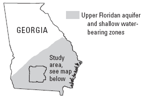
The objective of this study is to define geologic and hydrologic
characteristics and interconnection of the shallow water-bearing zones and the Upper Floridan aquifer. The study area includes eight counties in south-central Georgia (see map, upper right). Field work for this study includes:
- Inventory existing domestic and irrigation wells to
provide aquifer data in areas of sparse data coverage.
- Collect core samples and install test wells at selected sites.
- Evaluate paleontology and stratigraphy of core samples.
- Collect borehole geophysical logs in new and existing
wells to further define the stratigraphy and hydrogeologic characteristics of the area.
- Conduct aquifer tests in selected wells to determine
hydraulic properties and aquifer interconnection.
- Install continuous water-level recorders to establish fluctuations and trends in the shallow water-bearing zones.
Progress and Significant Results, 2006—2007
- Coweta County—Developed plan of study to include well inventory and borehole geophysical logging in selected wells.
- Forsyth County— Collected borehole geophysical logs and conducted borehole flowmeter traverse in two wells located along the Chattahoochee River north of Littles Ferry Bridge. Developed plan of study for well-inventory program.
- Oconee County— Collected borehole geophysical logs, grab water samples, and conducted borehole flowmeter traverse in two wells near the town of Watkinsville to evaluate causes of water-quality problems in the well water. In one well, dissolved carbon dioxide was being emitted; water in the
other well was contaminated by iron bacteria.
- Troup County— Completed compilation of data and field well inventory. Data for 138 wells were added to the existing 79-well NWIS database, which increased the total to 217 wells. Developed spatial hydrological data layers for wells and surficial geology. Began preparation of final report.
- Rockdale County— Collected borehole geophysical logs in two test wells located adjacent to production wells in the Conyers area to determine structural orientations of fractures and bedrock foliation. This information was used to help assess the interconnection between test wells and production wells as a follow-up to aquifer testing conducted during 2005 (Williams and Cressler, 2007).
- Other areas—In addition to the efforts in each of these counties, borehole geophysical logs were collected at several other sites in the Piedmont and Blue Ridge Provinces,
including two wells in White County, one well in Habersham County, and one well in Madison County.
- Outreach—Prepared a Fact Sheet describing how borehole geophysical logs can provide valuable information to evaluate ground-water resources in fractured crystalline rock (U.S. Geological Survey, 2007). The Fact Sheet describes the types of data collected and how these data are used to evaluate the water-bearing characteristics of fractured crystalline rock.
See https://pubs.usgs.gov/fs/2007/3048/.
 During the drought conditions of 2007, ground-water-level declines in south-central Georgia have resulted in numerous domestic wells "going dry," requiring pumps to be lowered or drilling of replacement wells. The cause of the declines is unknown but could be related to reduced recharge during the drought, increased pumping from the Upper Floridan aquifer, or a combination of both. Data from the Statewide ground-water monitoring network indicates that ground-water levels have declined more than 30 feet in the past 30 years (see graph, lower right). Additional data were needed to better define the geologic and hydrogeologic characteristics and the interconnection between the shallow water-bearing zones and the Upper Floridan aquifer.