Geohydrology and Effects of Climate and Pumpage Change on Water Resources of the Aucilla–Suwannee–Ochlockonee River Basin, South-Central Georgia and Adjacent Areas of Florida, Progress and Significant Results, 2006—2007
Project Chief: Lynn Torak
Cooperator: Georgia Department of Natural Resources
Year started: 2006
THIS PROJECT HAS BEEN COMPLETED AND IS BEING ARCHIVED IN ITS FINAL CONFIGURATION
Problem
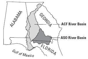
Episodic droughts and increased pumpage since the mid-1970s have caused unprecedented ground-water level decline in the Upper Floridan aquifer in much of the roughly 8,000 square-mile Aucilla-Suwannee-Ochlockonee (ASO) River Basin. Recent drought has triggered record-low ground-water levels during October 2006 in Charlton, Cook, Tift, Ware, and Worth Counties. A 25-foot water-level decline during the first 10 months of 2006 in Lowndes County nearly negated a post-drought recovery of that amount since 2003. Eastward relocation of municipal pumpage at Cairo, Georgia, during late 1973, reversed 35 feet of ground-water-level decline that occurred during the previous 7 years, giving the appearance of stable-to-increasing ground-water levels.
Increased center-pivot irrigation during the early 1990s along the boundary of the ASO River Basin with the neighboring Apalachicola-Chattahoochee-Flint (ACF) River Basin intercepts ground water previously available to recharge the ASO River Basin as regional (interbasin) flow and accelerates ground-water-level decline in the Upper Floridan aquifer. Drought- and pumpage-induced ground-water-level decline in the Upper Floridan
aquifer reduces the hydraulic gradient along the boundary of the ASO and ACF River Basins, which reduces regional ground-water (interbasin) flow to the south and east into the ASO River Basin. Recent pumpage increases threaten the ability of managers to meet current and future demand and increase the potential for reduced spring flow, base flow (ground-water discharge to streams), and interbasin flow from the north and west.
Objectives
The primary objective is to evaluate the occurrence and quality of ground water in fractured crystalline rock of the Piedmont and Blue Ridge physiographic provinces of northern Georgia. Specific objectives are to:
- Improve current understanding of the lithology and hydraulic properties of the Upper Floridan aquifer and hydraulically connected geologic units that enable assessment of ground-water and surface-water exchange.
- Identify spatial and temporal distributions of agricultural-irrigation pumpage from the Upper Floridan that define growing-season variability and cause-and-effect relations of agricultural pumpage to streamflow decline in the basin.
- Develop a hydrogeologic framework and conceptual model for evaluating agricultural pumpage and ground-water and surface-water exchange between the Upper Floridan aquifer and other hydrologic units connected to surface water.
- Collect and compile ground-water-level and streamflow measurements to provide an overview of current hydro-
logic conditions.
- Develop a conceptual understanding of ground-water and surface-water exchange mechanisms and causal relations between ground-water pumpage in the Upper Floridan aquifer, ground-water-level decline, reductions in streamflow and spring flow, and changes in interbasin flow.
Progress and Significant Results, 2006—2007
- Measured ground-water levels at about 350 wells, and stream stage and discharge at 83 stations during
September 19-29, 2006.
- Mapped potentiometric-surface and stream influence on Upper Floridan and surficial aquifers, September 2006.
- Evaluated and compiled existing hydrologic, geologic, climate, and pumpage information.
- Data collection and compilation thus far indicate
- Complex geologic structure and variations in hydraulic properties create diverse patterns of ground-water flow and recharge in the Upper Floridan aquifer and govern the hydraulic connection and water exchange between the Upper Floridan and surficial aquifers and surface water. Low water-transmitting properties of the Gulf Trough–Apalachicola Embayment limit regional flow and recharge to the aquifer in the Trough-Embayment region.
- Infiltration of precipitation and surface water in the karst region along the Florida–Georgia State line provides recharge to the Upper Floridan aquifer in the ASO River Basin located to the south and east of the Gulf Trough.
- Comparison of historical potentiometric surfaces since the late-1960s indicates changes in ground-water-flow directions across the boundary between ASO and ACF River Basins that coincide with increased agricultural-irrigation pumpage and drought.
- Ground-water hydrographs indicate basinwide response to variations in climate and pumpage despite little hydraulic connection of the Upper Floridan aquifer to land surface and surface water in areas of the Gulf Trough and Okefenokee Swamp.
Reference
Torak, L.J., and Painter, J.A. 2006, Geohydrology of the lower Apalachicola -
Chattahoochee-Flint River Basin, southwestern Georgia, northwestern Florida, and southeastern Alabama: U.S. Geological Survey Scientific Investigations Report 2006-5070, 80 p.; Web-only publication available at https://pubs.usgs.gov/sir/2006/5070/.
