
South Atlantic Water Science Center
South Atlantic Water Science Center
THIS PROJECT HAS BEEN COMPLETED AND IS BEING ARCHIVED IN ITS FINAL CONFIGURATION
by Federal Investigative Board
December 21, 1977
[Note: Click on the link to view the image. The photographs were scanned from color photocopies in the original report. When higher-quality copies of the same or similar photographs are available, links to those are given below the photograph from the Investigative Board report.]
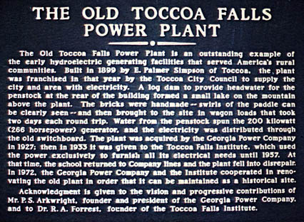
1. Historical plaque at old powerhouse building below Toccoa Falls.
2. Photograph in the 1948 Forrester, Toccoa Falls College annual, showing construction work in progress at Kelly Barnes Dam.
3. Photograph taken by construction worker (also student at Toccoa Falls College) showing work in progress on Kelly Barnes Dam. The spillway and penstock intake structures are shown. The photograph was developed in June, 1949 but the date that the photograph was taken is not known.
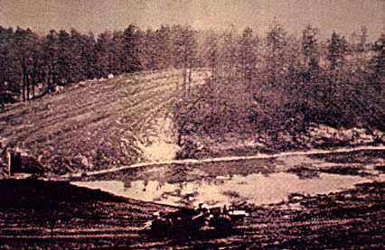
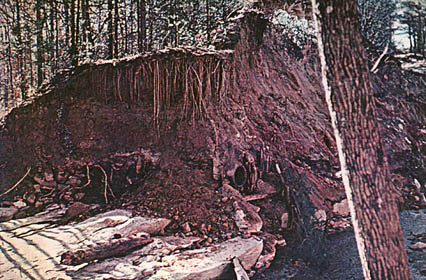
4. Aerial view of the area in the vicinity of Kelly Barnes Dam after the failure. The empty reservoir is shown in the lower portion of the photograph. Buildings in the Toccoa Falls College area can be seen near the right edge of the photograph about midway between the bottom and top edges. Dam and main earth spillway are located about one inch to left of photo center; secondary spillway is located about one inch below photo center.
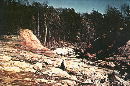
5. Aerial view of the breached dam looking downstream. The old campfire site, where undisturbed newspapers were found after failure, can be seen in the cleared area near the left edge of the photograph. The exposed rock surfaces, scoured clean by the flood, can be seen in and downstream from the breach. A tension crack is on the crest of the left face of the breach. Silt layers can be observed on the right face of the breach. Vegetation is shown on both sides.
6. View looking from the lake bed downstream through the breach. Breach is in the central portion of the photograph.
7. View of main earth spillway on the left abutment looking downstream. The sides of the spillway are shown to be heavily grown up with vegetation.
8. View of left face of breach.
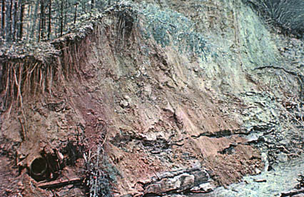
9. View of right face of breach. The opened flange face of the 30-inch spiral riveted steel pipe (old penstock) is shown in the lower left side of the photo. The layers of silt are shown to the right of the pipe. An extensive root system extending into the dam embankment is shown on the upper left portion of the photograph.
10. Another view of the right face of the breach. The opened flange face of the 30-inch spiral riveted steel pipe is shown slightly to the right and slightly below the center of the photograph. The extensive root system into the dam embankment is shown in the upper portion. An area of rock and rubble is shown on the left side of the photograph. A log, secured to the underlying rock with a steel pin is shown in the lower left portion of the photograph.
11. View of low spot in reservoir rim which served as a secondary spillway (looking toward the lake bed).
12. View looking across downstream slope of dam showing slope failure. Photograph taken in 1973. Man shown in the center of the picture is standing at the bottom of the slope failure.
13. View of downstream slope (photograph taken in 1973) showing slope failure with two-foot scarp in lower left portion of picture and heavy vegetation throughout.